Purchases of our 2025 PA Calendar and PA Amusement Parks Book

2025 PA Calendar & PA Amusement Parks Book Purchase Options
Showing posts with label Lancaster Covered Bridges. Show all posts

12.16.2024

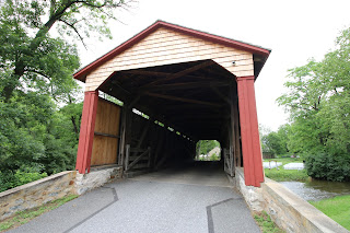
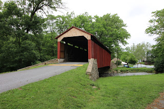
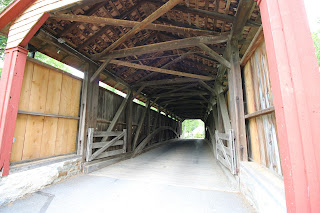
Leaman Place/Eshelman's Mill/Paradise Covered Bridge, Lancaster County

Leaman Place Covered Bridge in Lancaster County, also known as Eshelman's Mill and the Paradise Covered Bridge is a scenic span in one of the counties with the most abundant selections of covered bridges within Pennsylvania. Lancaster County has one of the finest collections of covered bridges in the state. At 113 feet long, this would be a decently sized span anywhere else, but there are much longer bridges both in the county and in the immediate area around central PA. 
This bridge crosses Pequea Creek and is a single-span burr-truss bridge. It was built by James Carpenter way back in 1845. It has been rehabilitated at numerous times, with its most thorough recent work being in 2004. 
It is close to the eastern edge of Lancaster County, just off Route 30 and Lincoln Highway Corridor in a more rural part of the county, in the heart of its agrarian center. It is located just off the edge of the village of Intercourse. 
As a covered bridge connoisseur, I am often most drawn to bridges with beautiful stone abutments like this. These approaches are so beautiful and are often more impressive to me than just the spans themselves. 

It is located on Belmont Road in Gordonville, right on the edge of Intercourse and Lancaster County. For more articles on Lancaster County's covered bridges, check out our set of articles. 

Our 2025 Pennsylvania Calendar is now available
Our 2025 Pennsylvania Wall Calendar features scenes from across the state, including views of:
-Knoebels Amusement Resort
-Center City Philadelphia 
-Forksville Covered Bridge and Big Mike's Cheesesteaks near Worlds End State Park
-Ricketts Glen State Park
-Downtown Pittsburgh
-PA's Elk Herd 
-Waldameer and Water World in Erie
-Lehigh Gorge Scenic Railway in Jim Thorpe, PA
-Linn Run State Park
-Kennerdell Overlook above the Allegheny River
-Ohiopyle State Park
-PA Grand Canyon

The calendars open up to be 17 inches tall by 11 inches wide (8.5 by 11 pages) and all photos have been taken by us, and the calendars are produced in the USA. The proceeds help us to continue what we do to highlight and bring attention to the many great adventures that this state has to offer.  They are available through the dropdown menu at the top of the page

5.05.2024

Bucher's Mill Covered Bridge: Lancaster County

Bucher's Mill Covered Bridge is a beautiful little covered bridge in Lancaster County across Cocalico Creek. For a guide on other covered bridges in Lancaster County, the county with the most covered bridges in PA, check out our guide. This little covered bridge has white portals with red sides. I am usually indifferent about what color the portals of a covered bridge are, but I have to say that the white portals on this bridge really pop with the lush greenery of the surrounding woods. On one end of the bridge, you approach the covered bridge by going through agricultural areas, very much in line with many of the other covered bridges in the region.
In a nut shell, between the agricultural area with a farm stand and immediately adjacent creek area with nice forests, this spot accentuates so much about small borough/suburban/rural Pennsylvania life, right down to small businesses, housing developments, and even a pickup truck accessories store, used car lot, pizza shop, and more within a quarter mile radius of this spot. If I had to pick one location that accentuates a lot of what the state consists of, this would be it. 


It is located on the outskirts of Ephrata. It was built in 1891 and is 54 feet long. It utilizes Burr Arch-Truss construction. 

Coordinates:

40.207940, -76.134756

4.14.2024

Weaver's Mill Covered Bridge: Lancaster County

Weaver's Mill Covered Bridge is surrounded by agricultural land in Lancaster County. For a guide on other covered bridges in Lancaster County, the county with the most covered bridges in PA, check out our guide. 

I particularly like the large stone entry ways leading up to the bridge. 

The bridge is 82 feet long and dates back to 1879. It utilizes the Burr Arch-Truss method of construction and it crosses the Conestoga River.

Coordinates: 
40.141323, -75.997804

3.20.2022

Poole Forge Covered Bridge and Poole Forge Historic Complex, Lancaster County

I adore the Poole Forge Covered Bridge and the Poole Forge complex. The bridge dates back to 1859 and is 99 feet long. It crosses the Conestoga River within the historic Poole Forge complex. The complex itself dates back into the 1779. When we visited the bridge, we could not stay too long because the grounds of the park area were being set up for a wedding. We were taken by surprise by just how historically intact this complex is. Well worth a visit to check out. It serves as both a living museum of 18th and 19th century industry, and a green space and park area that you are free to hike, walk your dog at, fish, bicycle and picnic on the lush grounds. 
The bridge itself gets a lot of attention from the foremost organization in covered bridge appreciation, preservation, and enthusiasm, the Theodore Burr Covered Bridge Society. 
Seldom do you find a covered bridge that remains with the primary reasons for its construction still remaining visible and able to be accessed. Many covered bridges are remnants of a different time and were built for industrial purposes that remain a mystery today, such as mills and old places of production. Often the mills have been demolished and the covered bridge remains as a reminder of what was there. this is not the case at Poole Forge, for the industrial village that surrounds it is pretty intact and thriving with activity as a public recreational and gathering spot. The vision that they had in preserving this bridge and community were absolutely brilliant. That was illustrated as we visited this place on a Saturday in June and it was buzzing with activity as a wedding was being set up for on the grounds. 


2.07.2021

Mercer's Mill Covered Bridge: Lancaster and Chester Counties

Mercer's Mill Covered Bridge crosses the East Octoraro Creek, bridging the divide between Chester and Lancaster Counties. It is breathtakingly beautiful. I know I say that about many covered bridges, but this one is truly beautiful. Statistically, it is pretty close to average for the Lancaster and Chester County regional covered bridges. It dates back to 1880 and is in a beautifully rugged creek valley and forest. 
Because of its placement in the valley, it just sneaks up on you. Tight curves lead to the top of the valley on either side of the covered bridge, leading to it just showing up. I always go out of my way to visit covered bridges when I am routing drives, but even with knowing the location of this covered bridge, it still was a surprise to see it. Covered Bridges like this, within the kind of setting it is located, are always my favorite in regards to the surrounding stunning scenery. The rugged surroundings are also a surprise because most of the driving you will do to get to the covered bridge will be through beautiful rolling hills and farmland.
The bridge was built in 1880 by Carter and utilizing a double Burr arch style construction with iron reinforcements. It is right on the edge of the pristine Wolf's Hollow County Park, which is home to a stone farm house that was built by the early German farmers that settled the area. The park is home to some nice hiking and lots of 18th and 19th century industrial remnants that have since been reclaimed by nature. There are lots of beautiful examples of covered bridges surrounding here, with 44 in all, 29 in Lancaster County, and 15 in Chester County. Of all of these covered bridges though, this one sticks out as one of my favorites.

 Coordinates: 39.93150, -75.98150


6.16.2019

Colemanville Covered Bridge, Lancaster County

Colemanville Covered Bridge is one of Lancaster County's many great covered bridges. It is a giant span that crosses Lancaster County's Pequea Creek. It is one of the longest covered bridges in the state, with a span length of 156 feet. While still over a hundred feet shorter than the state's longest covered bridge, the Academia-Pomeroy Covered Bridge in Juniata County, this span is still quite large. One of the most impressive aspects of this bridge is the fact that the community came together to rebuild the bridge so future generations could enjoy it and the scenic beauty that surrounds it. 
This section of the Pequea Creek Valley/Gorge is abrupt and rugged, making this area especially scenic and bucolic. This bridge has a double burr-arch design, and was originally built in 1856. Due to flooding issues, the bridge was raised by six feet and moved a few feet westward when it was completely rebuilt by Lancaster County in 1992. 
This giant bridge is impeccably maintained and is well worth checking out, especially when checking out the multitude of other covered bridges within Lancaster County. Additionally, there are many nice hiking opportunities within a short distance of the bridge, including the adjacent Fox Hollow Nature Preserve and Trolley Trail, and the nearby Conestoga Trail, Wind Cave, House Rock Nature Preserve, and the Tacquan Glen Nature Preserve. This is a beautiful area to explore.
Coordinates:
39.899001, -76.342078

1.18.2016

PA Covered Bridge Journey: Lancaster Covered Bridges

We continue our covered bridge tour across the state with a journey through Lancaster County, the county that has the most covered bridges within the state with a grand total of 29. 

Forry's Mill Covered Bridge: Coordinates: 40.0677° N, 76.4780° W

Here is Forry's Mill Covered Bridge across Chiques Creek in West Hempfield Township. It dates back to 1869 and measures in at 103 feet long. It is named after the Forry family, who lived in the stately stone house you can see in the background. 
Forry's Mill Covered Bridge - Built in 1869

Siegrist's Mill Covered Bridge: Coordinates 40.0759° N, 76.4711° W

Our next stop is at Siegrist's Mill Covered Bridge. This span measures in at 91 feet long and dates back to 1885. It crosses Chiques Creek and connects West Hempfield and Rapho Townships. This was one of the few bridges to survive the 1972 Hurricane Agnes Flood. It was damaged in the 2011 floods and was heavily renovated afterwards. They did some awesome work with the renovation, with the new lumber smell within the bridge really being pretty awesome.
Siegrist's Mill Covered Bridge - Built in 1885

Schenck's Covered Bridge: Coordinates 40.1156° N, 76.4253° W 

I really loved Schenck's Covered Bridge. The window features on the ends are really neat, along with the horizontal boards, and the rounded approaches. I realize that these are not unique features in covered bridges, but something about this bridge in particular really stood out to me. This bridge crosses Chiques Creek and measures in at 80 feet on the span, and 96 feet total length.
Schenck's Mill Covered Bridge - Built in 1855
Kauffman's Distillery Covered Bridge: Coordinates 40.1482° N, 76.4098° W
Kauffman's Distillery Covered bridge is 96 feet long and dates back to 1857. It was associated with the Kauffman Family, who ran a local distillery. It is said that they traveled around by wagon and sold their whiskey from town to town. I was at this bridge around rush hour, and it was pretty cool seeing how this bridge is used just as heavily as any other bridge. It is still in excellent shape and it adds a ton of character to the area.
Kauffman's Distillery Covered Bridge - Built in 1857

Erb's Covered Bridge: Coordinates 40.1678° N, 76.2439° W

Erb's Covered Bridge crosses Hammer Creek. It measures in at 80 feet and dates back to 1849. It is located near Rothsville, PA.
Erb's Covered Bridge - Built in 1849
We lost our daylight around this point, but we will continue on our covered bridge tour with covered bridge stops in Lehigh, along with Berks, Schuylkill, and Juniata Counties on the return trip back to the western part of the state.
Blogger Widget